The Piako Catchment
Wild Piako
Although our catchment has been heavily impacted by human activities, is still retains a range of natural treasures that we all have a responsibility to care for. In the Kopuatai peat dome, we have a globally significant wetland, while what we do in our catchment affects the world-renowned shore-bird feeding grounds in the Firth of Thames into which our river flows.
Historically, the floodplain forests of the Hauraki plains attracted huge flocks of kereru and kaka when the kahikatea trees were in full fruit. The Piako is home to some of the last remnants of these ancestral forests making us uniquely placed to recapture the former glory of this almost completely vanished ecosystem.
We are also blessed with extensive areas of native forest in the hills surrounding our catchment – Pukemokemoke, Maungakawa and Te Miro. Members of our community are working hard to protect these few remaining tracts of in-tact forest from pest plants and animals.
The future is bright for native plants and animals in the Piako. We have greatly benefited from broader conservation efforts in the Waikato, with nesting pairs of iconic birds like tui rapidly increasing. Kaka are noisy winter visitors, with Morrinsville being a favourite hangout. The native long-tailed bat also uses the remnant forests along our waterways to move through the landscape. We perhaps don’t realise the range of natural treasures we have. If we work together, we have a great opportunity to make our natural treasures a growing source of pride for our community and to preserve these treasures for generations to come.
Water Quality
Background
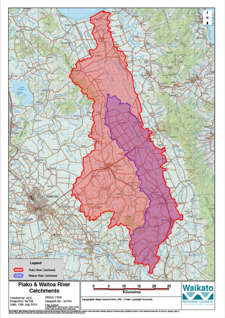
The Piako River is a lowland river system that drains into the Firth of Thames on the North Island of New Zealand. Together with the Waihou River, it is one of the two main rivers systems which drains the Hauraki Plains. It is the dominant river system in the Matamata-Piako District, and on its journey it passes through the towns of Morrinsville and Ngatea.
The Piako River has an annual mean flow of 17 cubic metres per second (600 cu ft/s) (at Paeroa-Tahuna Road), with a total catchment area of approximately 1,440 square kilometres (560 sq mi). The river system is approximately 100 kilometres (62 mi) long, aligned in a north-south direction and occupies much of the central and western Hauraki Plains (or more broadly, the Thames Valley), extending from Hinuera in the south before discharging into the Firth of Thames in the north, five kilometres west of Thames.
The Piako River has two major stems: the first, and main, stem drains the northern Te Miro-Tahuroa hills, and the Pakaroa Range. The dominant tributaries on the eastern slopes of these hills are the Piakonui and Piakoiti Streams. These streams, together with the smaller Toenepi Stream, converge just south of Kereone to become the Piako River. The western slopes are drained by the Waitakaruru Stream which joins the Piako River at Morrinsville. As the Piako River progresses north, it is fed by numerous small streams draining the eastern slopes of the Hangawera Hills.
The second stem is the Waitoa River, which starts near Piarere. The Waitoa River catchment drains the Hinuera Flats and broad southern Hauraki Plains, before converging with the Piako River in the large wetland known as the Kopuatai Peat Dome, northeast of Tahuna. The Upper Piako River catchment also drains the eastern aspects of the Hapuakohe Range through small tributaries.
The Piako river catchment is one of the most intensive agricultural districts in New Zealand. This has had, and continues to have, intense impacts on water quality in the streams and rivers of the catchment. However, there is some evidence that water quality indicators are improving.
A summary of water quality monitoring data is provided below.
Water quality monitoring data
- The Waikato Regional Council monitors water quality indicators at 10 locations throughout the Piako catchment.
- Water quality is monitored at 6 sites.
- Ecological data (invertebrates living on the stream bottom) are collected from 6 sites. The diversity and types of invertebrates present are used as indicators of aquatic ecosystem health.
- Both water and ecological data are collected at two sites.
Overview: Ecological indicators
- Ecological indicators varied from poor to excellent condition.
- Excellent sites were in headwaters dominated by native vegetation, while poor sites were in lowland pastoral catchments.
- For most sites there is no clear trend for increases or decreases in condition.
Overview: Water quality
- Almost all sites were in the bottom 50% of comparable sites for E. coli, turbidity, total nitrogen and total phosphorous.
-Total phosphorous and nitrogen were particularly poor, with 5/6 sites in the bottom 25% for phosphorous and 4/6 in the bottom 25% for nitrogen.
-However, total phosphorous is generally decreasing (i.e. improving) for all but one site.
-Total nitrogen is decreasing (improving) for 3 sites, increasing in 1 site and showing no clear trend at two sites.
-No trend data are currently available for E. coli
A summary on monitoring data for the Piako catchment is available on the Land Air and Water Aotearoa (LAWA) website:
https://www.lawa.org.nz/explore-data/waikato-region/river-quality/piako-river/
River flows
The Piako River contributes around 25% of the water flowing from the Hauraki plains into the Firth of Thames. So what we do in our catchment has a big impact on the marine environment too.
The flow rates in the southern, upstream end of our catchment fluctuate quite a bit with variation in rainfall relative to downstream areas. This is due to differences in geology. Permeable volcanic sediments occur close to the surface in upstream areas, allowing rainfall to flow deep into the groundwater in upstream areas, while impermeable sediments in downstream areas drive ground water from further upstream to the surface, thus buffering river flow rates against drought.
A recent water budget estimate completed for WRC put total inflows in the Piako catchment at 57.6 m 3 s -1 (cubic metres per second) with 38.3 m 3 s -1 (or over 1200 km 3 per year) lost to evaporation and plant uptake. The vast majority of the remainder – 18.5 m 3 s -1 (580 km 3 per year) – flows in to thefirth of Thames.
Freshwater fish
According to the New Zealand freshwater fish database, a total of 21 species have been recorded in the Piako catchment – 23 if you include koura and freshwater shrimp. This isn’t bad considering only 50 species of freshwater fish occur in all of New Zealand (NIWA Atlas of Freshwater Fishes).
Of these species 14 are native, including both native eel species (longfin and shortfin), banded and giant kokopu and several species of bullies (red-finned and Cranston’s).
The black mudfish is worthy of a special mention, since the Piako is one of its historical strongholds. It’s a hardy battler that can survive waterways that dry out for part of the year.
The major exotic species are the bullhead catfish, goldfish and gambusia (mosquito fish) which all thrive in the low-oxygen, sediment laden waters of the lower reaches of the Piako and in drainage canals.
Gambusia is guilty of false advertising as it is more likely to eat the fry and juveniles of native fish species than mosquitos!
The vast majority of native fish records in the freshwater fish database date back to the 1990’s or earlier, so it is unclear what the current state of native fish populations is.
Geology and soils
Although the Piako we see now is a peaceful landscape most notable for the leisurely grazing of dairy cows, it hasn’t always been this way. The catchment has been involved in some of the most dramatic events in New Zealand’s geological history, and these events continue to shape the land and soils on which our lives are based.
Geology
- Piako catchment comprises the western part of the Hauraki plains.
- The Hauraki plains are formed in the Hauraki Rift, a continental rift filled with sediments of either volcanic or marine origins.
- Hauraki plains are bound to the east by extinct volcanos of Coromandel range, Kaimais and Mamaku plateau.
- To the west, the plains are bordered by basement sedimentary rocks of the Hapuakoe and Pakaroa ranges.
- The Waikato river flowed through the Hauraki plains (via the “Hinuera gap”) for up to 300,000 years. Thus, much of the sediment on which the plains sit originally comes from gravel sand and mud transported from the Taupo volcanic zone.
- The Waikato adopted its present course following a huge eruption at Lake Taupo (15 times bigger than the famous eruption in 1200 A.D.), which eventually caused a debris flood covering the Hauraki plains in sediments up to 25m deep and blocking the Hinuera gap.
- Following this sediment deposition in the Hauraki plains was primarily from the Waihou, Waitoa and Piako catchments.
- Between Waitoa village and the Firth of Thames, the plains are only a few metres above sea level. This has led to impeded drainage contributing to widespread peat formation throughout the plains. The most striking example of this is the Kopuatai peat dome – a world
heritage wetland conservation site.
- The deep volcanic settlements of the plains mean that groundwater flows make a major contribution to river discharge, especially outside major rainfall events.
Soils
- The varied geology of the Piako catchment lead to a wide variety of soils.
- To the west we have clays derived from sedimentary rocks.
- In the main Piako catchment large areas of well-poorly drained clays or loams
- Peaty soils predominate in the west (around Eureka) and north (from Kopuatai peat dome and around Ngatea).
- In the Waitoa sub-catchment, which forms the eastern side of the Piako catchment, a range of poorly-drained loams predominates. The Waitoa catchment generally lacks peaty soils, except where it joins the Piako river at the southern end of Kopuatai peat dome.